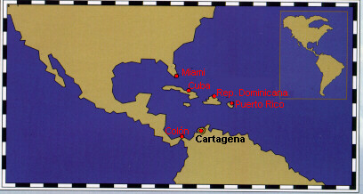
coast, roughly half a way from the Panama border on the west, and theVenezuela on
the east. The city is known for being both a place full of history, quite unique in
Latinamerica, and Colombia's most fascinating city.
(COLOMBIA) (map of Colombia)
GEOGRAPHICAL LOCATION
| Cartagena de Indias is located
in the middle of the 1600 km long Colombian Caribbean
coast, roughly half a way from the Panama border on the west, and theVenezuela on the east. The city is known for being both a place full of history, quite unique in Latinamerica, and Colombia's most fascinating city. |
|
HISTORY
| Cartagena was founded in 1533
by Pedro de Heredia. It quickly grew into a rich
town but in 1552
a fire destroyed a large number of its wooden buildings. Since that time only stone, brick and tile have been permitted as building materials. Within a short time the town blossomed again into the main Spanish port on the Caribbean coast and the gateway to all of northern South America. It was the storehouse for the treasure plundered from the Indians until the galleons could ship it back to Spain. No wonder then that Cartagena became a tempting target for all sorts of buccaneers marauding the Caribbean Sea. In the 16th century alone the town suffered five dreadful sieges by pirates, the most famous (or infamous) of which was headed by Sir Francis Drake. He sacked the port in 1586 and `mercifully' agreed not to burn the town to the ground once he was presented with a huge ransom of 10 million pesos, which he shipped back to England. It was in response to pirate attacks that the Spaniards decided to make Cartagena an impregnable port and constructed elaborate walls encircling the town, and a chain of outer forts to protect it. These fortifications made the city unique in South America and helped to save Cartagena during the fiercest and biggest attack of all, headed by Edward Vernon in 1741. He launched an offensive with a fleet of 186 ships, over 2000 cannons and about 25,000 men. The defence was commanded by Don Blas de Lezo. In spite of the high price it had to pay for the pirate attacks, Cartagena continued to flourish. The Canal del Dique, constructed in 1650 to connect Cartagena Bay with the Magdalena River, made the town the main gateway forships to the ports upriver, and a large part of the shipped inland passed through Cartagena. The town was also granted a royal monopoly as a slavetrading port. During the long colonial period, Cartagena was the most important bastion of the Spanish overseas empire and influenced much of Colombia's history. The indomitable spirit of the inhabitants
was rekindled again at the time of
the independence movement. Cartagena was
one of the first towns to proclaim independence from
Spain early in 1810, which prompted Bogota and
other cities to do the same. The declaration was signed
on 11 November 1811, but the city eventually paid dearly for it.
Spanish forces under Pablo Morillo were
In August 1819 Simon Bolivar's troops
defeated the Spaniards at Boyaca and brought freedom to Bogota.
However, Cartagena had to wait for its liberation until October 1821 when
the patriot forces eventually took the city from the sea. It was
Bolivar who gave Cartagena its well deserved name of `La Heroica', the
Heroic City. Cartagena soon began to recover
and was shortly once again the trading and shipping centre of South America.The
city's prosperity attracted foreign immigrants, and many Jews, Italians,
French, Turks, Lebanese and Syrians settled here. Today their
descendants own many of the hotels
and restaurants, particularly in Bocagrande. Over
the past decades
|
CLIMATE
| Cartagena's climate is typically Caribbean, with its average
annual temperature of 28 degrees Celsius, changing very little throughout
the year. Although the days are hot, a fresh breeze blows in the
even-
ings making it a pleasant time to stroll around the city. The dry season lasts approximately from November to April; the rest of the year is wetter. Mean annual rainfall is about 900mm. |
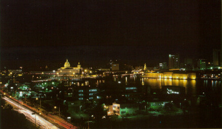
ORIENTATION
| The heart of the city is the old town, facing the sea to
the west and almost entirely separated by water from the mainland to the
east.The old town was built in two sections, creating an inner and
outer town. Both were surrounded by walls
and separated from each other by a channel,
the Caño de San Anastasio. The channel was filled
up to make way for the construction of the sharp, wedge-shaped,
modern district, La Matuna.
The inner walled town, towards the west, is bigger than the outer one. It consists of El Centro, in the south, where traditionally the upper classes lived, and San Diego, in the north, previously occupied by the middle classes. The outer walled town, Getsemani, once inhabited by the lower end of the social ladder, is smaller and understandably poorer, with more modest architecture. Outside the walled town several monumental fortresses still stand. Stretching south of the old town is an unusual, L-shaped peninsula, occupied by three districts: Bocagrande, Castillo Grande and El Laguito. These are relatively new suburbs but are developing fast. The coastline of the peninsula has limited the city's spread, so growth has turned vertical, and today the area boasts a collection of high-rise buildings. Bocagrande and El Laguito have developed into up-market holiday resorts, becoming the main destinations for affluent Colombians and international charter tours. These areas are now packed with top-class hotels, posh restaurants, boutiques and nightspots. |
OLD TOWN (map)
 |
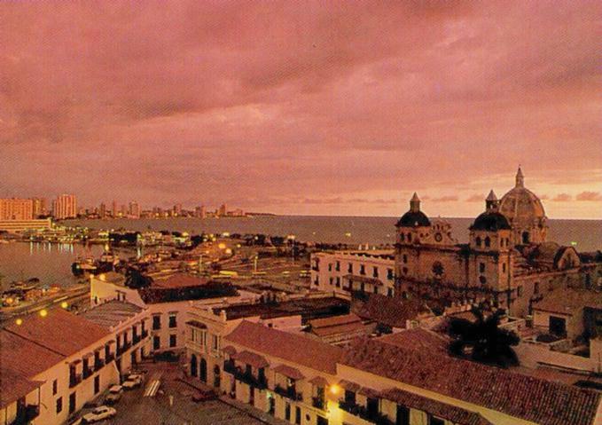
Obviously, the old city is the
principal attraction,
particularly the inner walled town. It is a real gem of colonial architecture, packed with churches, monasteries, plazas, palaces and noble mansions with their overhanging balconies and shady patios. Getsemani, the outer walled town, is not so well preserved and less impressive, but has some charming places and is well worth exploring. It is less tourist oriented and more authentic. However, visitors should take extra precautions for this part of the city is not that safe. |
| The old town is sorrounded by thick
walls, the Murallas, built to protect it
against enemies.
Construction began towards the end of the 16th century after the attack by Francis Drake (until that time Cartagena was completely unprotected) but the project was to take two centuries to complete due to repeated damage from storms and pirate attacks. Only in 1796 was it finally finished, 25 years before the Spaniards were eventually expelled. The Murallas are an outstanding piece of military engineering and
they are well worth visiting. Only a handful of the walls of walled
cities in the world are preserved in such good condition as those of
Cartegena. A part of the wall facing La Matuna
|
 |
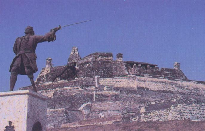
SPANISH FORTS
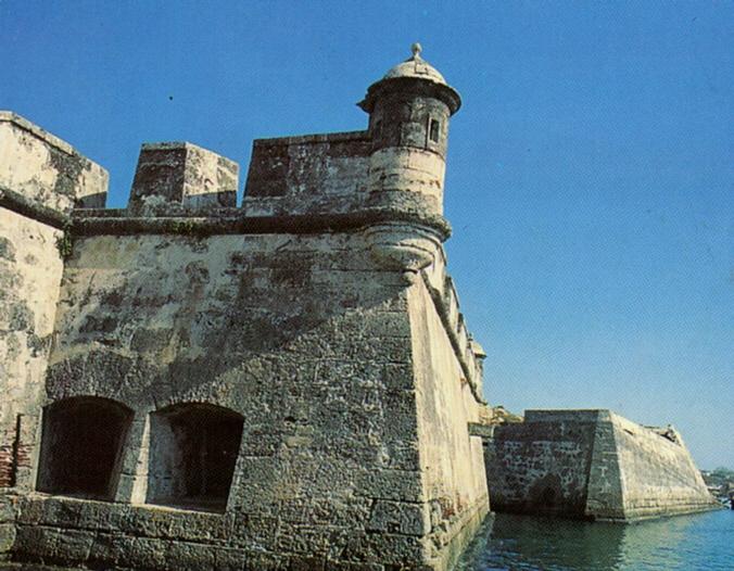 |
The old city is a fortress in
itself, yet there are more
fortifications built in strategic points outside the city. Some of the more important ones are included below. Castillo de San Felipe de Barajas.This is undoubtedly the greatest and strongest fortress ever built by the Spaniards in their colonies. The original fort was constructed between 1639 and 1657 on top of the 40m high San Lazaro hill, and was quite small. In 1762 an extensive enlargement was undertaken which eventually resulted in the entire hill being covered over with this powerful bastion. It was truly impregnable and was never taken despite numerous attempts to storm it. |
|
The fortress is another outstanding piece of military engineering. The batteries were arranged so that they could destroy each other if the fort fell to the enemy. A complex system of tunnels connects strategic points of the fortress to distribute provisions and to facilitate evacuation. The tunnels were constructed in such a way that sounds reverberate all the way along them, making it possible to hear the slightest sound of the approaching enemy's feet, and also making it easy for internal communication. Some tunnels are lit and are open to visitors - a walk not to be missed. |
 |
RESTAURANTS
| Cartagena has many classy restaurants. As might be expected,
seafood is the main local food and most
restaurants have a list of seafood delicacies on their menus, particularly the cazuela de mariscos. Restaurante La Tinaja in La Matuna is a pleasant open-air place specialising
in grilled meats. It also
Restaurante La Quemada in El Centro is not bad for seafood either,
and has a nicer atmosphere. The
El Bodegon de la Candelaria, in a marvellous colonial mansion, is
well known for its good cuisine. Try
Paco's, on the Plaza de Santo Domingo, has a rather short menu, with
the food being very good but not
A short walk south will lead you to the Restaurante Classic de Andrei
and La Escollera de la Marina,
Should you fancy some Chinese cuisine, the Kon Nam, in La Matuna,
and El Drag6n de Oro, a few paces
Bocagrande has yet more to offer and has more ethnic variety. La
Pampa is unbeatable for juicy churrasco,
|
AROUND CARTAGENA (map)
| La Boquilla
This is a small, poor fishing village 7km north of Cartagena. It lies at the end of a narrow peninsula bordered by the sea on one side and the Cienaga de Tesca on the other. The entire population is black and lives off fishing. You can see them at the cienaga working with their famous atarrayas, a round fishing net that is very common in Colombia, particularly on the Caribbean coast. Palm-thatched shack restaurants on the beach attract people from Cartagena on weekends. They are almost all closed at other times. The fish is fresh but not as cheap as you might expect here given the proximity of the ocean. It is usually accompanied by arroz con coco, rice prepared with coconut milk. You can arrange a boat trip along the narrow channels cutting through the mangrove woods to the north of the village. Several locals offer canoe trips, taking around five people at a time. |
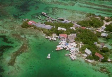
Islas del Rosario (map)
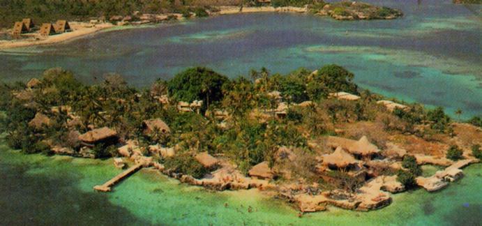 |
This archipelago
of small coral islands is about 35
km
south-west of Cartagena. There are about 25 islands altogether, including some tiny islets only big enough for a single house. The archipelago is surrounded by coral reefs, where the colour of the sea ranges from turquoise to purple. The whole area has been declared a national park, the Corales del Rosario. |
| The coral reefs around
the Islas del Rosario are
the largest and most magnificent on the Colombian Caribbean coast, comparable to those in San Andres and Providencia. Marine life is abundant in the surrounding waters, making the area a paradise for snorkelling and scuba diving. The two largest islands have inland lagoons. An aquarium has been built on the Isla de San Martin.The driest period in the region is from December to March, while the wettest is from September to October. |
 |
| Volcan de Lodo el Totumo
About 1/2 hour from Cartagena, on the bank of the large
but shallow Cienaga del Totumo, one can find an
|
Return to Silafae-III main page.